Community feedback
We engaged with the local community from June-August 2021 to better understand how the space was used and what future improvements were important to meet your needs and aspirations for the reserve.
The Master Plan was developed through a collaborative and consultative process, involving project partners, Traditional Owners, local community and businesses. We engaged with the local community from June-August 2021 and this feedback helped shape the plan.
The Greening the Pipeline (Zone 9 Brooklyn) Master Plan has now been finalised and is available for public viewing.
We engaged with the local community from June-August 2021 to better understand how the space was used and what future improvements were important to meet your needs and aspirations for the reserve.
Read the Master Plan for Greening the Pipeline (Zone 9 Brooklyn) and how it will transform the Brooklyn area into a productive, recreational landscape with multiple benefits for the community.
We will be working with our project partners to pursue funding opportunities. The scope and staging of the master plan’s implementation will be dependent on funding availability. In the meantime, planning and assessment work for Zone 9 will continue.
Engagement for the Master Plan has now been completed. When we move forward into future design stages, we will ask the local community to provide input on different aspects of the project. Make sure to follow this page to be notified when this occurs.
The Main Outfall Sewer reserve, also referred to as the Pipeline Reserve and/or Federation Trail, spans 27kms from Werribee to Spotswood. To effectively manage design, delivery and planning for the transformation of the reserve it has been split into nine zones.
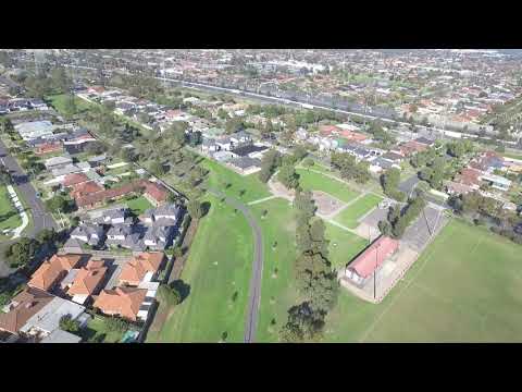
The 2.7km section that makes up the Greening the Pipeline Brooklyn project area is known as Zone 9. View the aerial drone footage and map for a detailed view.
Click here to view a map of all Greening the Pipeline zones.

Map of the project area (Zone 9)
Melbourne Water respectfully acknowledges the Bunurong, Gunaikurnai,
Taungurung, Wadawurrung and Wurundjeri Woi-wurrung peoples as the Traditional
Owners and Custodians of the land and water on which we rely and operate.
We
pay our deepest respects to their Elders - past, present and emerging.